Residents encouraged to help draft a local neighbourhood plan for Salt River, Woodstock
04 May 2023
The City of Cape Town
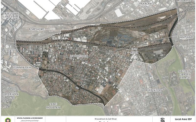
is busy preparing the local spatial development framework, or neighbourhood
plan, for Woodstock and Salt River, inclusive of University Estate and Walmer
Estate. Residents, businesses, and interested and affected parties are
encouraged to participate in the crafting of this plan that is intended to
revitalise the area by addressing key challenges and building on its unique
strengths.
'A local spatial development framework, or LSDF, is a very important plan as it determines the development vision for an area on a local level. The City uses the LSDF for guidance when making decisions about development applications and land uses; and in the end, these decisions very much determine what a neighbourhood will look and feel like a few years down the line.
'Woodstock and Salt River have experienced major changes over the past decade. These changes are partly because of the neighbourhood's proximity to the Cape Town central business district and associated private investment, the impact of the Covid-19 pandemic on the local economy, as well as the City's intention to create affordable housing opportunities that will see new families moving into the neighbourhood.
'The LSDF for Woodstock and Salt River will attempt to re-establish this unique neighbourhood, to strengthen the sense of belonging and place through protecting and enhancing the area's heritage value, to grow as a multi-cultural and integrated community, revitalise public open spaces and parks that have been neglected, stimulate the local economy through an appropriate spatial development vision, and to integrate and connect Woodstock and Salt River with the surrounding areas,' said the City's Deputy Mayor and Mayoral Committee Member for Spatial Planning and Environment, Alderman Eddie Andrews.
The City is now busy drafting the LSDF, and will host a number of engagements with the local community and broader public. The materials and outcomes of the first of these sessions, held in the Woodstock Town Hall in the second week of April 2023, are available for downloading at: https://www.capetown.gov.za/City-Connect/Have-your-say/Issues-open-for-public-comment/register-to-participate-in-the-woodstock-salt-river-lsdf.
'We want to tap into the knowledge and experience of the local residents and businesses. These are the people who know the area inside-out, and have a deep understanding of the community and its dynamics. I encourage all to attend the upcoming meeting, and to give us your comment on the strengths, weaknesses, opportunities, and other ideas you may want to see included in the draft LSDF. Officials will also be present to answer questions about the process going forward,' said Alderman Andrews.
The City's Urban Planning and Design Department is hosting a public meeting where the groundwork will be presented:
- Date: Saturday, 13 May 2023
- Time: from 10:00 to 14:00
- Venue: Salt River Community Hall
- Those who want to receive regular updates on the drafting of the LSDF are encouraged to register online at: https://bit.ly/3NvuwRB, or visit the Subcouncil 16 office to complete and submit the registration form
- Those who live and work in Woodstock, Salt River, Walmer Estate and University Estate are also encouraged to complete an online survey about their experiences and knowledge of the area on the City's website by 31 May 2023
- For more information, send an email to WSR.LSDF@capetown.gov.za
The public's contributions will be used to finalise the draft LSDF and thereafter it will be advertised for public comment, and further refinement.
The future growth of Salt River and Woodstock must take into account:
- A diverse mix of land uses
- The Heritage Protection Overlay Zone affecting extensive parts of the area
- The historical routes of Albert Road and Victoria Road
- Key tourism attractions such as Trafalgar Park, Woodstock Cave, street art, fashion and creative hubs, food and entertainment
- Its topography with some parts 136m above sea level on the steeper slopes and 4m above sea level on the flatter parts
- Its accessibility through Main Road and Voortrekker Road, and the convergence of major passenger rail lines
- Affordable housing for a growing and diverse community with varying income levels and household sizes
- Transit-oriented development along main roads, at public transport stations and stops
- The need for safe walking and cycle routes
- The need for social and public facilities, and public spaces to support residential growth
The purpose and intention of an LSDF for Woodstock and Salt River:
- to guide the City's decisions on the type of developments that should happen, and how land should be used
- create certainty for public and private investors
- formulate a development vision of what these area should look like in future
- develop and promote the tourism industry to help stimulate sustainable economic growth
- promote the area as a high quality tourist destination, in addition to other existing industries
- promote partnerships to strengthen the local economy
Interesting facts:
- Woodstock was developed from three farms – Zonnebloem, Leliebloem, and Roodebloem – on the slopes of Devil's Peak in 1692
- It was originally named Papendorp, but the name was changed to Woodstock in 1867
- Woodstock became a trendy seaside suburb after a railway line was developed in the mid-19th century. The beach stretched all the way to the Castle of Good Hope at that time
- Given its good location, Woodstock experienced rapid growth, and increased industrialisation in the late 1800s
- The Biscuit Mill opened in 1900, and was relaunched as a creative enterprise space in the 2000s
- The Foreshore reclamation project in the 1950s cut off the seaside and beach access
The Woodstock and Salt River LSDF elaborates on and supports the spatial development guidelines as set out in the Table Bay District Spatial Development Framework, which is a higher order plan for the greater Table Bay area that includes Woodstock and Salt River.
Caption: The local spatial development framework, or neighbourhood plan, for Woodstock and Salt River, includes the suburbs of University Estate and Walmer Estate. The map clearly indicates the study area. Residents from these suburbs are encouraged to attend the information day on 13 May 2023 at the Salt River Community Hall.
End
Published by:
City of Cape Town, Media Office